SPOT
A macroplastic emission inventory using bottom-up waste and resource management data, SPOT is ideal for baselining, monitoring, hotspotting and development of local to national action plans
The Spatio-temporal quantification of Plastic pollution Origins and Transportation (SPOT) model, is a fully integrated GIS-based model for highlighting hotspots of plastic pollution across the world. Written in R-language, the model has been applied on a global scale (publication to be released shortly) but can also be applied at higher resolution over any region with dedicated data inputs for enhanced reliability.
Municipal solid waste generation; collection coverage; proportion of collected and managed in controlled facilities (SDG11.6.1); plastic emissions to the environment.
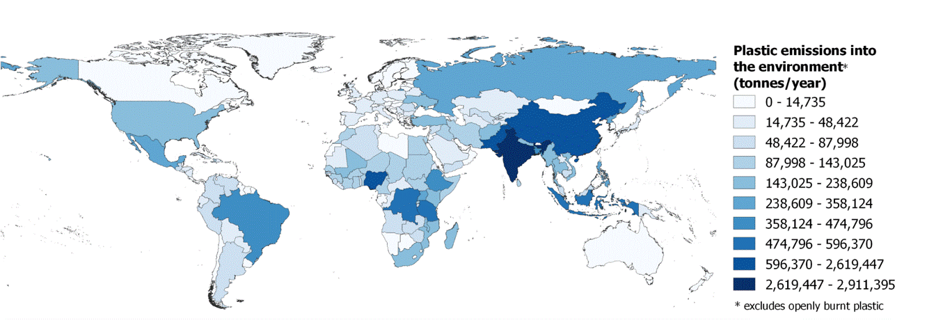
SPOT uses measured municipal scale activity data and socio-economic variables to predict data for locations where reliable data have not been obtained using quantile regression random forest machine learning. These predicted data are used to populate a random probabilistic material flow analysis model (Monte Carlo) which maps the flow of plastic waste across planet earth, from the movement it is generated through the complex and diverse global systems. The model estimates plastic waste emissions from five system components in 60,000 municipalities worldwide.

Spatial allocation of data, prediction, and material flow analysis
The highly granular mapping of plastic waste emissions enables us to highlight plastic pollution hotspots. Policymakers can then target, often scarce resources where they will be most effective.
Unlike many other models, SPOT treats both open burning and debris as separate emission types because the behavioural causes, environmental and health impacts are different. Open burning of plastic waste is emerging as a major threat to human health and the environment, with some estimates indicating that more than a quarter of all plastic waste generated is combusted in open uncontrolled fires.
The outputs of SPOT are aligned with SDG11.6.1 which means it can be used for baselining and continuous monitoring of progress towards achievement of targets. We have already collaborated with the UNSD and UN-Habitat to compile the global estimate for SDG 11.6.1.
Once emissions have been estimated across the study area, SPOT maps material movement at raster resolution. The probability of movement is based on wind speed, surface runoff, land use, terrain and river networks. The physical properties of plastic items are also considered. Larger, dense items may never move, whereas lighter flexible plastics have a high probability of being affected by meteorological forces and gravity.
The terrestrial transport component of the SPOT model maps the flow of plastic waste from the point of emission through to its retention on land, or discharge into the aquatic environment
Our sophisticated transport modelling is able to determine the point of entry into rivers and oceans for plastic debris that has been transported across land. We are also able to pinpoint areas of accumulation, sinks, where the probability of movement is minimal ('the entangled domain'). The SPOT model is able to provide spatial hotspot maps of an areas plastic pollution whether related to its origins (e.g. source), pathways (e.g. rivers) or fate (e.g. marine litter).